Friends of Betty MacDonald
For fans of this beloved American writer
| • | • | • | • |
The Map and I

Scroll down for various maps of "Egg Country."
Readers have tried to identify precisely the places Betty MacDonald wrote about. Because most are probably composites, it's very hard to correlate fiction with actual places.
The maps on this page show the location of Chimacum, WA, relative to Puget Sound and nearby cities. The red star in each shows the location of Chimacum. The last (largest scale) shows the general location of The Egg and I Farm off Beaver Valley Road. This is all about an hour from Seattle except at 5 PM on a Friday, when it takes a week. Click the maps for larger views.
For you non-Washington folks, only the east (Puget Sound) side of the Chimacum area is easily accessible by water, Port Townsend via WA State ferry and Port Hadlock (don't blink, you'll miss it) and Port Ludlow and a few smaller private docks by private boat. Most of the named waterfront towns were lumber ports built in the mid-19th century.
Northern Puget Sound
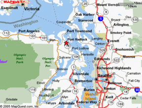
Port towns of the Olympic and Kitsap peninsulas surrounding Chimacum. Although located much farther north than Maine, this area has mild winters and cool, dry summers.
Modern ferry service links the peninsula to the mainland from Port Townsend on the Olympic Peninsula and from Kingston, Bainbridge and Bremerton on the Kitsap Peninsula. However, in the 1930s there were still remnants of the "mosquito fleet" of private ferries and boatmen landing elsewhere.
The most direct route to Seattle is to drive to Bainbridge Island (AKA Winslow) on Route 3 and go straight to Elliott Bay and downtown Seattle. Today (2005) the trip from Colman Dock in Seattle to Chimacum via Bainbridge Island takes under two hours. However, the floating bridge over the Hood Canal on Rte. 104 was not built until 1961, and the trip surely took much longer in the 1920s.
Port Townsend is a more direct local route but puts the traveler ashore in Keystone, which Ma Kettle might have described as "a far piece" from Seattle by car. The compromise choice is Rte. 104 via Kingston across to Edmonds.
Betty MacDonald's "Docktown" is probably a composite of Port Hadlock, Port Ludlow and perhaps Port Townsend, all of which have in 70 years metamorphosed into resorts and retirement centers. Her "Town" is probably Port Townsend. Distances to other Olympic Peninsula towns would have been considered prohibitive in the 1920s.
Chimacum and Vicinity
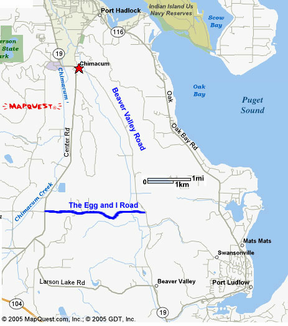
At a larger scale, local roads show increasing sub-urbanization scarcely imagined in Betty's time. Port Ludlow's gated communities have relatively few chicken farms.
The Egg and I farm is in Beaver Valley, which runs south and east from Chimacum, pretty much on the road to nowhere but leading by a series of turns to Kingston, which leads by ferry to Edmonds and then south to Seattle. Ya pays yer money and ya takes yer choice.
Note that "The Betty MacDonald Farm" easily found on the Web, is where Betty did her writing many years after leaving Chimacum. It is on Vashon Island, accessible south and west of Seattle via the Fauntleroy-Vashon ferry - shown on Puget Sound (first) map in orange.
DISCOVERY, JULY 2006: In the US Census of 1930, head of household Cleveland Bard, his mother Elsie and sisters Darcie D and Alison are listed in Center, WA, which is a crossroads west of Port Ludlow and is only a couple of miles from the farm on E&I Road.
By the way, you'd hate living here in the Puget Sound country. It rains all the time.
FA
FA